Click on the County
![]()
|
County |
County seat |
Established |
Origin |
Etymology |
Population (2010) |
Area (2010) |
Map |
|---|---|---|---|---|---|---|---|
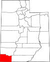
| Beaver County | Beaver | 1856 | Part of Iron County | The many beavers in the area | 6,629 | 2,590 sq mi |
 |
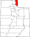
| Box Elder County | Brigham City | 1856 | Part of Weber County | The many Box Elder trees in the area | 49,975 | 5,746 sq mi |
 |
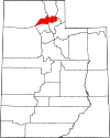
| Cache County | Logan | 1857 | Part of Weber County | Caches of furs made by Rocky Mountain Fur Company trappers | 112,656 | 1,165 sq mi |
 |
| Carbon County | Price | 1894 | Part of Emery County | The vast coal beds in the county. | 21,403 | 1,478 sq mi |
 |
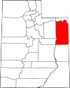
| Daggett County | Manila | 1919 | Part of Uintah County | Ellsworth Daggett (1810–1880), the first Utah Surveyor General | 1,059 | 697 sq mi |
 |
| Davis County | Farmington | 1850 | Originally State of Deseret | Daniel C. Davis (1804–1850), Mormon Battalion Captain | 306,479 | 299 sq mi |
 |
| Duchesne County | Duchesne | 1913 | Part of Wasatch County | Origins are likely a Ute word "dark canyon", the French and Indian War site of Fort Duquesne the name of an area Indian chief, or the name of French fur trapper and explorer. | 18,607 | 3,241 sq mi |
 |
|
|
|||||||
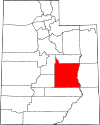
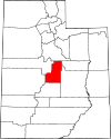
| Emery County | Castle Dale | 1880 | Part of Sanpete County | George W. Emery (1830–1909), Governor of the Utah Territory from 1875–1880 | 10,976 | 4,462 sq mi |
 |
| Garfield County | Panguitch | 1882 | Part of Iron County | James A. Garfield (1831–1881), President of the United States in 1881 | 5,172 | 5,175 sq mi |
 |
| Grand County | Moab | 1890 | Part of Emery County | The Grand River, since renamed to the Colorado River | 9,225 | 3,672 sq mi |
 |
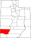
| Iron County | Parowan | 1850 | Original county of State of Deseret | Iron mines west of Cedar City. | 46,163 | 3,297 sq mi |
 |
| Juab County | Nephi | 1852 | Original county of Territory of Utah | A Native American word translated "thirsty valley" | 10,246 | 3,392 sq mi |
 |
| Kane County | Kanab | 1864 | Part of Washington County | Thomas L. Kane (1822–1883), U.S. Army Officer who spoke in favor of the Mormon migration and settlement of Utah | 7,125 | 3,990 sq mi |
 |
|
|
|||||||
| Millard County | Fillmore | 1851 | Original county of Territory of Utah | Millard Fillmore (1800–1874), President of the United States from 1850 to 1853 | 12,503 | 6,572 sq mi |
 |
| Morgan County | Morgan | 1862 | Part of Davis County | Jedediah Morgan Grant (1816–1856), an Apostle of The Church of Jesus Christ of Latter-day Saints | 9,469 | 609 sq mi |
 |
| Piute County | Junction | 1865 | Part of Beaver County | The Piute tribe of Native Americans who lived in the area | 1,556 | 758 sq mi |
 |
| Rich County | Randolph | 1864 | Part of Cache County | Charles C. Rich (1809–1883), an Apostle of The Church of Jesus Christ of Latter-day Saints | 2,264 | 1,029 sq mi |
 |
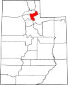
| Salt Lake County | Salt Lake City | 1849 | Original county of State of Deseret | The Great Salt Lake, the largest terminal lake in the Western Hemisphere | 1,029,665 | 742 sq mi |
 |
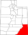
| San Juan County | Monticello | 1880 | Parts of Kane, Iron, and Piute counties | Named for the San Juan River, a 400-mile tributary of the Colorado river located in Southern Colorado and Utah | 14,746 | 7,820 sq mi |
 |
| Sanpete County | Manti | 1849 | Original county of State of Deseret | Uncertain, possibly from a Ute Chief named San Pitch | 27,882 | 1,590 sq mi |
 |
|
|
|||||||
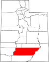
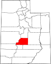
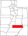
| Sevier County | Richfield | 1862 | Part of Sanpete County | The Sevier River, a 280-mile river in central Utah | 20,802 | 1,911 sq mi |
 |
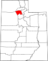
| Summit County | Coalville | 1854 | Part of Salt Lake and Green River counties | High elevations in the county, which includes 39 of Utah's highest peaks | 36,324 | 1,872 sq mi |
 |
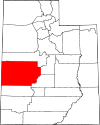
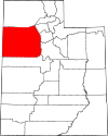
| Tooele County | Tooele | 1849 | Original county of State of Deseret | Uncertain, either from the Goshute Tribe Chief Tuilla or the Tules plant that grew in the marshes | 58,218 | 6,941 sq mi |
 |
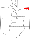
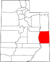
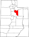
| Uintah County | Vernal | 1880 | Part of Wasatch | The Uintah band of the Ute tribe who lived in the area | 32,588 | 4,480 sq mi |
 |
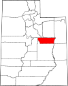
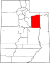
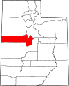
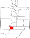
| Utah County | Provo | 1849 | Original county of State of Deseret | Yuta, the Spanish name for the Ute tribe | 516,564 | 2,003 sq mi |
 |
|
|
|||||||
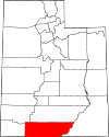
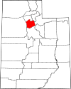
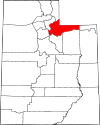
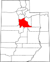
| Wasatch County | Heber City | 1862 | Part of Utah and Sanpete counties | A Native American word meaning "mountain pass", also the name of the Wasatch Range | 23,530 | 1,176 sq mi |
 |
|
1852 |
Original county of Territory of Utah |
George Washington (1732–1799), President of the United States from 1789 to 1797 |
138,115 |
2,426 sq mi |
|
||
|
1892 |
Part of Piute County |
Wayne Robinson, the son of Utah state legislator Willis Robinson, who was killed by a horse while both men traveled to a legislative session. |
2,589 |
2,461 sq mi |
|
||
|
|
Ogden | 1849 |
Original county of
|
The Weber River, a 125 miles tributary of the Great Salt Lake
|
231,236 | 576 sq mi |
 |
![]()